|
|
Antenna Structure Registration 1032297 |
 |
Registration Info | Registration Number: 1032297 |
| File Number: A0038299 |
| FAA Study: 98-ASW-1814-OE |
| FAA Issue Date: 05/14/1998 |
| Status: Constructed |
| Date Constructed: 09/10/1998 |
| NEPA: N |
Structure Info
| Structure Type: 4TA3 |
| Structure Coordinates: 29-31-50.0 N 98-7-17.0 W (NAD 83) |
| Structure Coordinates: 29-31-49.2 N 98-07-16.0 W (Converted to NAD 27) |
| Structure Address: Twr 3 0.84 Km W-nw Of Int Of Interstate 10 And State Rt 465 |
| Structure City: Santaclara, TX |
| Structure County: Guadalupe County |
| Painting & Lighting Info |
FAA Circular #: 70/7460-1J |
FAA Chapters: 3, 4, 5, 13 |
Remarks: Removed expiration date from determination. Scenario 1./jjs/case#635066 |
| Elevation Info |
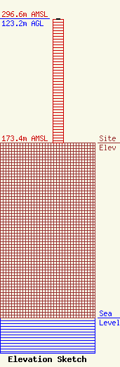
Site Elevation: 173.4 meters (569 ft) |
| Height of Structure: 122.3 meters (401 feet) |
| Overall Height Above Ground: 123.2 meters (404 feet) |
| Overall Height Above Mean Sea Level: 296.6 meters (973 feet) |
| Owner Info | SALEM MEDIA OF TEXAS, INC.
4880 SANTA ROSA ROAD,SUITE 300
CAMARILLO, CA 93012
(805) 987-0400
|
