|
|
Antenna Structure Registration 1032339 |
 |
Registration Info | Registration Number: 1032339 |
| File Number: A1366922 |
| FAA Study: 2011-AWP-403-OE |
| FAA Issue Date: 02/10/2011 |
| Status: Constructed |
| Date Constructed: 08/31/1999 |
| FAA EMI: N |
| NEPA: N |
Structure Info
| Structure Type: TOWER |
| Structure Coordinates: 38-52-33.0 N 121-7-34.0 W (NAD 83) |
| Structure Coordinates: 38-52-33.4 N 121-07-30.2 W (Converted to NAD 27) |
| Structure Address: E Hwy 80 Frm Roseville Chantry Hill Rd |
| Structure City: New Castle, CA |
| Structure County: Placer County |
| Painting & Lighting Info |
FAA Chapters: NONE |
Remarks: PRIOR STUDY 2008-AWP-3148-OE |
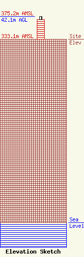
| Elevation Info |
Site Elevation: 333.1 meters (1093 ft) |
| Height of Structure: 36.6 meters (120 feet) |
| Overall Height Above Ground: 42.1 meters (138 feet) |
| Overall Height Above Mean Sea Level: 375.2 meters (1231 feet) |
| Owner Info | Pinnacle Towers LLC
2000 Corporate Drive
Canonsburg, PA 15317
(724) 416-2400
Regulatory.Department@crowncastle.com |
| Contact Info | Crown Castle
2000 Corporate Drive
Canonsburg, PA 15317
Tom Anderson
(724) 743-6330
Tom.Anderson@crowncastle.com |
