|
|
Antenna Structure Registration 1032648 |
 |
Registration Info | Registration Number: 1032648 |
| File Number: A1297344 |
| FAA Study: 2018-ACE-5249-OE |
| FAA Issue Date: 08/27/2018 |
| Status: Granted |
| Date Constructed: 08/01/1991 |
| NEPA: N |
Structure Info
| Structure Type: GTOWER |
| Structure Coordinates: 39-0-22.0 N 96-2-58.0 W (NAD 83) |
| Structure Coordinates: 39-00-22.0 N 96-02-57.0 W (Converted to NAD 27) |
| Structure Address: 5.0 Miles South Of |
| Structure City: Maple Hill, KS |
| Structure County: Wabaunsee County |
| Painting & Lighting Info |
FAA Circular #: 70/7460-1J |
FAA Chapters: 3, 4, 5, 13 |
Remarks: PRIOR STUDY 1997-ACE-1025-OE |
Remarks: OM&L to remain the same as prior study = PAINT/RED LIGHTS |
Remarks: PRIOR STUDY 1997-ACE-1025-OE |
Remarks: OM&L to remain the same as prior study = PAINT/RED LIGHTS |
| Elevation Info |
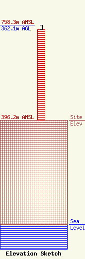
Site Elevation: 396.2 meters (1300 ft) |
| Height of Structure: 345 meters (1132 feet) |
| Overall Height Above Ground: 362.1 meters (1188 feet) |
| Overall Height Above Mean Sea Level: 758.3 meters (2488 feet) |
| Owner Info | Gray Local Media, Inc.
4370 Peachtree Road, NE
Atlanta, GA 30319
(404) 266-8333
legalnotices@graymedia.com |
| Contact Info | Gray Local Media, Inc.
4370 Peachtree Road NE
Atlanta, GA 30319
Engineering Department
(404) 266-8333
legalnotices@graymedia.com |
