|
|
Antenna Structure Registration 1032651 |
 |
Registration Info | Registration Number: 1032651 |
| File Number: A1094703 |
| FAA Study: 00-ACE-0120-OE |
| FAA Issue Date: 06/30/2000 |
| Status: Constructed |
| Date Constructed: 01/16/2004 |
| NEPA: N |
Structure Info
|
| Structure Coordinates: 39-3-50.0 N 95-45-50.0 W (NAD 83) |
| Structure Coordinates: 39-03-50.0 N 95-45-49.1 W (Converted to NAD 27) |
| Structure Address: 301 Nw Wanamaker Road |
| Structure City: Topeka, KS |
| Structure County: Shawnee County |
| Painting & Lighting Info |
FAA Circular #: 70/7460-1K |
FAA Chapters: 3, 4, 5, 12 |
Remarks: Removed final date from determination. Scenario 3./jjs/case#635066 |
| Elevation Info |
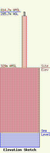
Site Elevation: 329 meters (1079 ft) |
| Height of Structure: 265 meters (869 feet) |
| Overall Height Above Ground: 285.7 meters (937 feet) |
| Overall Height Above Mean Sea Level: 614.7 meters (2017 feet) |
| Owner Info | WASHBURN UNIVERSITY OF TOPEKA
1700 SW COLLEGE AVENUE
TOPEKA, KS 66621
(785) 670-1111
gary.krohe@washburn.edu |
| Contact Info | Garvey Schubert Barer
1000 Potomac Street, N.W.
Washington, DC 20007
Lawrence Miller
(202) 298-2534
lmiller@gsblaw.com |
