|
|
Antenna Structure Registration 1032987 |
 |
Registration Info | Registration Number: 1032987 |
| File Number: A1107237 |
| FAA Study: 77-ANW-68-OE |
| FAA Issue Date: 04/02/1977 |
| Status: Constructed |
| Date Constructed: 03/01/1979 |
| FAA EMI: N |
| NEPA: N |
Structure Info
| Structure Type: TOWER |
| Structure Coordinates: 46-5-46.0 N 119-11-40.0 W (NAD 83) |
| Structure Coordinates: 46-05-46.5 N 119-11-36.0 W (Converted to NAD 27) |
| Structure Address: Johnson Butte |
| Structure City: Kennewick, WA |
| Structure County: Benton County |
| Painting & Lighting Info |
FCC Paragraph(s): 1, 3, 12, 21 |
Remarks: RED LIGHTS/PAINT |
| Elevation Info |
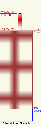
Site Elevation: 614.2 meters (2015 ft) |
| Height of Structure: 134.1 meters (440 feet) |
| Overall Height Above Ground: 135 meters (443 feet) |
| Overall Height Above Mean Sea Level: 749.2 meters (2458 feet) |
| Owner Info | SMG - Tri Cities, LLC
2448 E. 81st Street
Tulsa, OK 74137
(918) 492-2660
deborah.cox@smgok.com |
| Contact Info | SMG - Tri Cities, LLC
2448 E. 81st Street
Tulsa, OK 74137
Deborah Cox
(918) 492-2660
deborah.cox@smgok.com |
