|
|
Antenna Structure Registration 1033216 |
 |
Registration Info | Registration Number: 1033216 |
| File Number: A0143964 |
| FAA Study: 90-AEA-1684-OE |
| FAA Issue Date: 11/28/1990 |
| Status: Constructed |
| Date Constructed: 01/01/1990 |
| FAA EMI: N |
| NEPA: N |
Structure Info
| Structure Type: TOWER |
| Structure Coordinates: 38-30-12.0 N 75-39-39.0 W (NAD 83) |
| Structure Coordinates: 38-30-11.6 N 75-39-40.3 W (Converted to NAD 27) |
| Structure Address: Ralphs Cnr Rd |
| Structure City: Laurel, DE |
| Structure County: Sussex County |
| Painting & Lighting Info |
FAA Circular #: 70/7460-1G |
FAA Chapters: 3, 4, 5, 9 |
| Elevation Info |
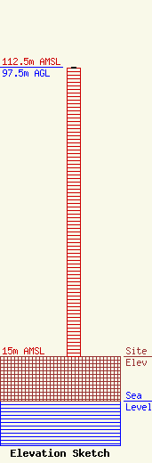
Site Elevation: 15 meters (49 ft) |
| Height of Structure: 97 meters (318 feet) |
| Overall Height Above Ground: 97.5 meters (320 feet) |
| Overall Height Above Mean Sea Level: 112.5 meters (369 feet) |
| Owner Info | GREAT SCOTT BROADCASTING
224 MAUGERS MILL ROAD
POTTSTOWN, PA 19464
(610) 970-1500
|
| Contact Info | GREAT SCOTT BROADCASTING
224 MAUGERS MILL ROAD
POTTSTOWN, PA 19464
MIKE LICATA
(610) 970-1500
|
