|
|
Antenna Structure Registration 1033297 |
 |
Registration Info | Registration Number: 1033297 |
| File Number: A0039501 |
| Status: Constructed |
| Date Constructed: 01/01/1939 |
| NEPA: N |
Structure Info
| Structure Type: TOWER |
| Structure Coordinates: 39-28-3.0 N 80-12-19.0 W (NAD 83) |
| Structure Coordinates: 39-28-02.7 N 80-12-19.7 W (Converted to NAD 27) |
| Structure Address: .95 Km Ne |
| Structure City: Monogah, WV |
| Structure County: Marion County |
| Painting & Lighting Info |
FCC Paragraph(s): 1, 3, 11, 21 |
| Elevation Info |
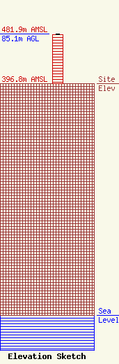
Site Elevation: 396.8 meters (1302 ft) |
| Height of Structure: 84.1 meters (276 feet) |
| Overall Height Above Ground: 85.1 meters (279 feet) |
| Overall Height Above Mean Sea Level: 481.9 meters (1581 feet) |
| Owner Info | FANTASIA BROADCASTING INC DBA = WMMN AM
450 LEONARD AVE
FAIRMONT, WV 26554
(304) 366-3700
|
