|
|
Antenna Structure Registration 1033300 |
 |
Registration Info | Registration Number: 1033300 |
| File Number: A1221621 |
| Status: Constructed |
| Date Constructed: 01/01/1994 |
| FAA EMI: N |
| NEPA: N |
Structure Info
| Structure Type: 4TA2 |
| Structure Coordinates: 38-0-0.0 N 100-53-54.0 W (NAD 83) |
| Structure Coordinates: 37-59-59.9 N 100-53-52.4 W (Converted to NAD 27) |
| Structure Address: Twr 2 - 8 Km Ene |
| Structure City: Holcomb, KS |
| Structure County: Finney County |
| Painting & Lighting Info |
FCC Paragraph(s): 1, 3, 11, 21 |
| Elevation Info |
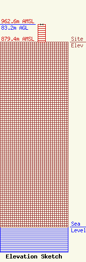
Site Elevation: 879.4 meters (2885 ft) |
| Height of Structure: 83.2 meters (273 feet) |
| Overall Height Above Ground: 83.2 meters (273 feet) |
| Overall Height Above Mean Sea Level: 962.6 meters (3158 feet) |
| Owner Info | Western Kansas Broadcast Center, LLC
1402 East Kansas Avenue
Garden City, KS 67846
(620) 276-2366
myearout@southwindbroadcasting.com |
| Contact Info | Western Kansas Broadcast Center, LLC
`402 East Kansas Avenue
Garden City, KS 67846
Mark Yearout
(620) 276-2366
myearout@southwindbroadcasting.com |
