|
|
Antenna Structure Registration 1033371 |
 |
Registration Info | Registration Number: 1033371 |
| File Number: A0781663 |
| FAA Study: 2012-ANM-1754-OE |
| FAA Issue Date: 07/31/2012 |
| Status: Constructed |
| Date Constructed: 01/01/1951 |
| FAA EMI: N |
| NEPA: N |
Structure Info
| Structure Type: 2GTA2 |
| Structure Coordinates: 48-43-18.2 N 122-26-44.7 W (NAD 83) |
| Structure Coordinates: 48-43-18.8 N 122-26-40.1 W (Converted to NAD 27) |
| Structure Address: Twr 2 - 2219 Yew St Rd |
| Structure City: Bellingham, WA |
| Structure County: Whatcom County |
| Painting & Lighting Info |
FCC Paragraph(s): 1, 3, 11, 21 |
Remarks: Continue As Is OM&L = PAINT/RED LIGHTS |
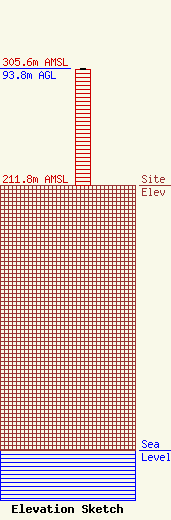
| Elevation Info |
Site Elevation: 211.8 meters (695 ft) |
| Height of Structure: 92.9 meters (305 feet) |
| Overall Height Above Ground: 93.8 meters (308 feet) |
| Overall Height Above Mean Sea Level: 305.6 meters (1003 feet) |
| Owner Info | Saga Broadcasting, LLC
73 Kercheval Avenue, Suite 201
Grosse Pointe Farms, MI 48236
(313) 886-7070
gurbiel@sagacom.com |
| Contact Info | Smithwick & Belendiuk, P.C.
5028 Wisconsin Avenue, NW Suite 301
Washington, DC 20016
Gary Smithwick
(202) 363-4050
gsmithwick@fccworld.com |
