|
|
Antenna Structure Registration 1033496 |
 |
Registration Info | Registration Number: 1033496 |
| File Number: A1013641 |
| FAA Study: 2005-ACE-623-OE |
| FAA Issue Date: 04/05/2005 |
| Status: Constructed |
| Date Constructed: 01/01/1983 |
| FAA EMI: N |
| NEPA: N |
Structure Info
| Structure Type: TOWER |
| Structure Coordinates: 37-6-28.0 N 95-43-23.0 W (NAD 83) |
| Structure Coordinates: 37-06-27.7 N 95-43-22.1 W (Converted to NAD 27) |
| Structure Address: 3.0 Km East-southeast Of Jefferson |
| Structure City: Jefferson, KS |
| Structure County: Montgomery County |
| Painting & Lighting Info |
FAA Circular #: 70/7460-1K |
FAA Chapters: 3, 4, 5, 12 |
Remarks: PRIOR STUDY 1999-ACE-933-OE |
| Elevation Info |
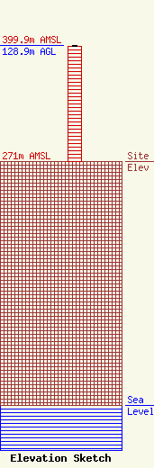
Site Elevation: 271 meters (889 ft) |
| Height of Structure: 128 meters (420 feet) |
| Overall Height Above Ground: 128.9 meters (423 feet) |
| Overall Height Above Mean Sea Level: 399.9 meters (1312 feet) |
| Owner Info | KCD Towers, LLC
1200 SE Frank Phillips Blvd.
P.O. Box 1100
Bartlesville, OK 74005
(918) 336-1001
kevin@bartlesvilleradio.com |
| Contact Info | Putbrese Hunsaker & Trent, P.C.
200 South Church Street
Woodstock, VA 22664
John Trent
(540) 459-7646
fccman3@shentel.net |
