|
|
Antenna Structure Registration 1033580 |
 |
Registration Info | Registration Number: 1033580 |
| File Number: A1119608 |
| FAA Study: 2006-ANM-473-OE |
| FAA Issue Date: 02/27/2006 |
| Status: Constructed |
| Date Constructed: 05/16/2006 |
| FAA EMI: N |
| NEPA: N |
Structure Info
| Structure Type: TOWER |
| Structure Coordinates: 46-50-23.0 N 122-15-31.0 W (NAD 83) |
| Structure Coordinates: 46-50-23.6 N 122-15-26.6 W (Converted to NAD 27) |
| Structure Address: .64 Km W Of Int Turner Scott Rd & E 444th St |
| Structure City: Eatonville, WA |
| Structure County: Pierce County |
| Painting & Lighting Info |
FAA Chapters: NONE |
Remarks: Removed expiration date from determination. Scenario 1./jjs/case#635066 |
Remarks: PRIOR STUDY 2000-ANM-991-OE |
Remarks: Removed expiration date from determination. Scenario 1./jjs/case#635066 |
Remarks: PRIOR STUDY 2000-ANM-991-OE |
| Elevation Info |
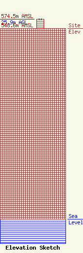
Site Elevation: 548.6 meters (1800 ft) |
| Height of Structure: 25.9 meters (85 feet) |
| Overall Height Above Ground: 25.9 meters (85 feet) |
| Overall Height Above Mean Sea Level: 574.5 meters (1885 feet) |
| Owner Info | Vertical Bridge CC FM, LLC
750 Park of Commerce Dr.
Boca Raton, FL 33487
(561) 406-4015
fcc-faa@verticalbridge.com |
| Contact Info | Vertical Bridge CC FM, LLC
750 Park of Commerce Dr.
Boca Raton, FL 33487
Richard Hickey
(561) 406-4015
fcc-faa@verticalbridge.com |
