|
|
Antenna Structure Registration 1033637 |
 |
Registration Info | Registration Number: 1033637 |
| File Number: A1213671 |
| FAA Study: 85-AEA-0437-OE |
| FAA Issue Date: 12/22/1987 |
| Status: Constructed |
| Date Constructed: 06/30/1985 |
| FAA EMI: N |
| NEPA: N |
Structure Info
|
| Structure Coordinates: 38-22-8.0 N 81-49-10.0 W (NAD 83) |
| Structure Coordinates: 38-22-07.7 N 81-49-10.5 W (Converted to NAD 27) |
| Structure Address: 2000' W Of Penn Ave Approx 1.25 Mi S Jct With Kanawha Ter |
| Structure City: Saint Albans, WV |
| Structure County: Kanawha County |
| Painting & Lighting Info |
FAA Circular #: 70/7460-1F |
FAA Chapters: 3, 4, 5 |
Remarks: RED LIGHTS/PAINT |
| Elevation Info |
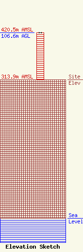
Site Elevation: 313.9 meters (1030 ft) |
| Height of Structure: 106.6 meters (350 feet) |
| Overall Height Above Ground: 106.6 meters (350 feet) |
| Overall Height Above Mean Sea Level: 420.5 meters (1380 feet) |
| Owner Info | LLoyd Hoff Holding Corp.
166 Jack Burlingame Dr.
Millwood, WV 25262
(130) 427-3279
support@lloydselectronics.com |
| Info |
