|
|
Antenna Structure Registration 1033701 |
 |
Registration Info | Registration Number: 1033701 |
| File Number: A0422263 |
| FAA Study: 98-AGL-2107-OE |
| FAA Issue Date: 06/02/1998 |
| Status: Constructed |
| Date Constructed: 12/09/1998 |
| FAA EMI: N |
| NEPA: N |
Structure Info
| Structure Type: 4TA1 |
| Structure Coordinates: 38-39-45.0 N 90-7-47.0 W (NAD 83) |
| Structure Coordinates: 38-39-44.8 N 90-07-46.6 W (Converted to NAD 27) |
| Structure Address: Twr 1 #1 Mueller Road |
| Structure City: Madison, IL |
| Structure County: Madison County |
| Painting & Lighting Info |
FAA Circular #: 70/7460-1J |
FAA Chapters: 4, 6, 13 |
Remarks: PRIOR FAA 97-AGL-3993-OE |
| Elevation Info |
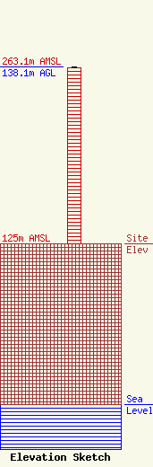
Site Elevation: 125 meters (410 ft) |
| Height of Structure: 136.8 meters (449 feet) |
| Overall Height Above Ground: 138.1 meters (453 feet) |
| Overall Height Above Mean Sea Level: 263.1 meters (863 feet) |
| Owner Info | KSD-AM, LLC DBA = KTRS AM
638 WESTPORT PLZ
SAINT LOUIS, MO 63146
(314) 453-5527
MIKEB1260@AOL.COM |
