|
|
Antenna Structure Registration 1034098 |
 |
Registration Info | Registration Number: 1034098 |
| File Number: A0040436 |
| FAA Study: CE-OE-66-767 |
| FAA Issue Date: 11/15/1967 |
| Status: Constructed |
| Date Constructed: 01/01/1970 |
| NEPA: N |
Structure Info
| Structure Type: TOWER |
| Structure Coordinates: 43-54-22.0 N 90-28-26.0 W (NAD 83) |
| Structure Coordinates: 43-54-22.1 N 90-28-25.5 W (Converted to NAD 27) |
| Structure Address: Cypress Lane S Of Tomah E Of Hwy 131 |
| Structure City: Tomah, WI |
| Structure County: Monroe County |
| Painting & Lighting Info |
FCC Paragraph(s): 1, 3, 12, 21 |
Remarks: RED LIGHTS/PAINT |
| Elevation Info |
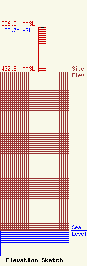
Site Elevation: 432.8 meters (1420 ft) |
| Height of Structure: 122.8 meters (403 feet) |
| Overall Height Above Ground: 123.7 meters (406 feet) |
| Overall Height Above Mean Sea Level: 556.5 meters (1826 feet) |
| Owner Info | VCY AMERICA INC
3434 W KILBOURN AVE
MILWAUKEE, WI 53208
(414) 935-3000
|
