|
|
Antenna Structure Registration 1034248 |
 |
Registration Info | Registration Number: 1034248 |
| File Number: A1248953 |
| FAA Study: 2023-ASO-1398-OE |
| FAA Issue Date: 07/13/2023 |
| Status: Constructed |
| Date Constructed: 04/24/1998 |
| NEPA: N |
Structure Info
| Structure Type: LTOWER |
| Structure Coordinates: 36-1-13.5 N 86-38-17.9 W (NAD 83) |
| Structure Coordinates: 36-01-13.3 N 86-38-17.9 W (Converted to NAD 27) |
| Structure Address: 5788 Cane Ridge Road (tn01984-a) |
| Structure City: Antioch, TN |
| Structure County: Davidson County |
| Painting & Lighting Info |
FAA Circular #: 70/7460-1K |
FAA Chapters: 4, 8, 12 |
Remarks: OM&L to remain the same as prior study = A MED-DUAL SYSTEM |
Remarks: PRIOR STUDY 2022-ASO-3343-OE |
Remarks: OM&L to remain the same as prior study = A MED-DUAL SYSTEM |
Remarks: PRIOR STUDY 2022-ASO-3343-OE |
| Elevation Info |
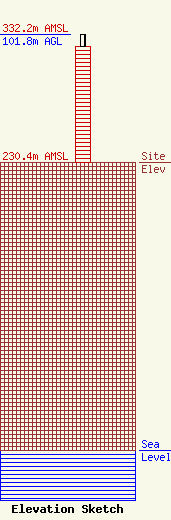
Site Elevation: 230.4 meters (756 ft) |
| Height of Structure: 92.7 meters (304 feet) |
| Overall Height Above Ground: 101.8 meters (334 feet) |
| Overall Height Above Mean Sea Level: 332.2 meters (1090 feet) |
| Owner Info | SBA Towers, LLC
8051 Congress Avenue
Boca Raton, FL 33487
(561) 995-7670
ERoach@sbasite.com |
| Contact Info | SBA Towers, LLC
8051 Congress Avenue
Boca Raton, FL 33487
(561) 995-7670
ERoach@sbasite.com |
