|
|
Antenna Structure Registration 1034891 |
 |
Registration Info | Registration Number: 1034891 |
| File Number: A1208875 |
| FAA Study: 98-ANM-0996-OE |
| FAA Issue Date: 01/25/1998 |
| Status: Constructed |
| Date Constructed: 01/01/1997 |
| NEPA: N |
Structure Info
|
| Structure Coordinates: 42-9-49.0 N 122-38-52.0 W (NAD 83) |
| Structure Coordinates: 42-09-49.5 N 122-38-47.9 W (Converted to NAD 27) |
| Structure Address: Twr 2 - 528 Reiten Drive |
| Structure City: Ashland, OR |
| Structure County: Jackson County |
| Painting & Lighting Info |
FCC Paragraph(s): 1, 3, 12, 21 |
| Elevation Info |
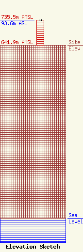
Site Elevation: 641.9 meters (2106 ft) |
| Height of Structure: 93.6 meters (307 feet) |
| Overall Height Above Ground: 93.6 meters (307 feet) |
| Overall Height Above Mean Sea Level: 735.5 meters (2413 feet) |
| Owner Info | ROGUE VALLEY BROADCASTING
2383 Johns Peak Road
Central Point, OR 97502
(541) 941-3847
johnsonk10@icloud.com |
| Contact Info | ROGUE VALLY BROADCASTING
2383 Johns Peak Road
Central Point, OR 97502
KAREN JOHNSON
(541) 941-3847
johnsonk10@icloud.com |
