|
|
Antenna Structure Registration 1034934 |
 |
Registration Info | Registration Number: 1034934 |
| File Number: A0041321 |
| Status: Constructed |
| Date Constructed: 08/01/1984 |
| NEPA: N |
Structure Info
| Structure Type: TOWER |
| Structure Coordinates: 42-5-48.0 N 121-38-1.0 W (NAD 83) |
| Structure Coordinates: 42-05-48.5 N 121-37-57.0 W (Converted to NAD 27) |
| Structure Address: Stukel Mt 15 Km Se |
| Structure City: Klamath Falls, OR |
| Structure County: Klamath County |
| Painting & Lighting Info |
FCC Paragraph(s): 1, 3, 11, 21 |
| Elevation Info |
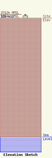
Site Elevation: 1954 meters (6411 ft) |
| Height of Structure: 37.8 meters (124 feet) |
| Overall Height Above Ground: 58 meters (190 feet) |
| Overall Height Above Mean Sea Level: 2012 meters (6601 feet) |
| Owner Info | CALIFORNIA OREGON BROADCASTING INC
125 S FIR
1489
MEDFORD, OR 97501
(541) 779-5555
|
