|
|
Antenna Structure Registration 1035134 |
 |
Registration Info | Registration Number: 1035134 |
| File Number: A1122372 |
| FAA Study: 3-OE-2661-1 |
| FAA Issue Date: 12/21/1962 |
| Status: Constructed |
| Date Constructed: 10/01/1963 |
| FAA EMI: N |
| NEPA: N |
Structure Info
| Structure Type: 5TA1 |
| Structure Coordinates: 42-56-44.0 N 88-3-39.0 W (NAD 83) |
| Structure Coordinates: 42-56-43.9 N 88-03-38.7 W (Converted to NAD 27) |
| Structure Address: Twr 1 11800 W Grange Ave |
| Structure City: Hales Corners, WI |
| Structure County: Milwaukee County |
| Painting & Lighting Info |
FCC Paragraph(s): 1, 3, 4, 13, 21 |
Remarks: RED LIGHTS/PAINT. TOWER 1 OF 2 TA. TWRS 1,2,3,4 AR 466 FT AGL. TWR 5 IS 406 FT AGL. |
| Elevation Info |
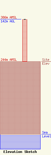
Site Elevation: 244 meters (801 ft) |
| Height of Structure: 140.2 meters (460 feet) |
| Overall Height Above Ground: 142 meters (466 feet) |
| Overall Height Above Mean Sea Level: 386 meters (1266 feet) |
| Owner Info | Entercom Wisconsin, LLC
401 E. City Avenue, Suite 809
Bala Cynwyd, PA 19004
(610) 660-5610
john.kennedy@entercom.com |
| Contact Info | Entercom Communications Corp.
1015 Half Street SE
Washington, DC 20003
Laura Berman
(484) 270-6312
laura.berman@entercom.com |
