|
|
Antenna Structure Registration 1035146 |
 |
Registration Info | Registration Number: 1035146 |
| File Number: A1306558 |
| FAA Study: 2024-AGL-14075-OE |
| FAA Issue Date: 01/15/2025 |
| Status: Constructed |
| Date Constructed: 02/17/2009 |
| NEPA: N |
Structure Info
| Structure Type: LTOWER |
| Structure Coordinates: 40-3-40.7 N 80-45-8.2 W (NAD 83) |
| Structure Coordinates: 40-03-40.4 N 80-45-08.9 W (Converted to NAD 27) |
| Structure Address: Twr 1 Kirkwood Hgts |
| Structure City: Bridgeport, OH |
| Structure County: Belmont County |
| Painting & Lighting Info |
FAA Circular #: 70/7460-1M |
FAA Chapters: 3, 4, 5, 15 |
Remarks: PRIOR STUDY 1996-AGL-764-OE |
| Elevation Info |
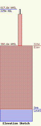
Site Elevation: 392.6 meters (1288 ft) |
| Height of Structure: 195 meters (640 feet) |
| Overall Height Above Ground: 225 meters (738 feet) |
| Overall Height Above Mean Sea Level: 617.6 meters (2026 feet) |
| Owner Info | Nexstar Media Inc.
545 E. John Carpenter Freeway
Irving, TX 75062
(972) 373-8800
jasroberts@nexstar.tv |
| Contact Info | Nexstar Media Inc.
545 E. John Carpenter Freeway
Irving, TX 75062
Jason Roberts
(972) 373-8800
jasroberts@nexstar.tv |
