|
|
Antenna Structure Registration 1035560 |
 |
Registration Info | Registration Number: 1035560 |
| File Number: A1146707 |
| FAA Study: 2015-AGL-16590-OE |
| FAA Issue Date: 12/14/2015 |
| Status: Constructed |
| Date Constructed: 12/16/2015 |
| NEPA: N |
Structure Info
| Structure Type: GTOWER |
| Structure Coordinates: 44-20-25.9 N 87-47-11.5 W (NAD 83) |
| Structure Coordinates: 44-20-25.9 N 87-47-11.2 W (Converted to NAD 27) |
| Structure Address: 6301 County Hwy P |
| Structure City: Denmark, WI |
| Structure County: Brown County |
| Painting & Lighting Info |
FAA Circular #: 70/7460-1L |
| FAA Chapters: 3, 4, 5, 12 |
| Remarks: PRIOR STUDY 1994-AGL-2240-OE. FAA Chapters 3,4,5,12; 70/7460-1K with FAA approved bird deviation special condition. |
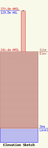
| Elevation Info |
Site Elevation: 241.4 meters (792 ft) |
| Height of Structure: 128.6 meters (422 feet) |
| Overall Height Above Ground: 129.5 meters (425 feet) |
| Overall Height Above Mean Sea Level: 370.9 meters (1217 feet) |
| Owner Info | Woodward Communications Inc.
2800 East College Avenue
1519
Appleton, WI 54912-1519
(920) 831-5659
sbrown@wcinet.com |
| Contact Info | Woodward Communications Inc.
2800 East College Avenue
1519
Appleton, WI 54912-1519
(920) 831-5659
sbrown@wcinet.com |
