|
|
Antenna Structure Registration 1035768 |
 |
Registration Info | Registration Number: 1035768 |
| File Number: A1157696 |
| FAA Study: 74-EA-1332-OE |
| FAA Issue Date: 12/23/1974 |
| Status: Dismantled |
| Date Constructed: 01/01/1975 |
| FAA EMI: N |
| NEPA: N |
Structure Info
|
| Structure Coordinates: 39-14-47.0 N 81-28-18.0 W (NAD 83) |
| Structure Coordinates: 39-14-46.7 N 81-28-18.6 W (Converted to NAD 27) |
| Structure Address: Nr Rt 50 Washington Hwy At Red Hill |
| Structure City: Parkersburg, WV |
| Structure County: Wood County |
| Painting & Lighting Info |
FCC Paragraph(s): 1, 3, 11, 21 |
Remarks: RED LIGHTS/PAINT |
| Elevation Info |
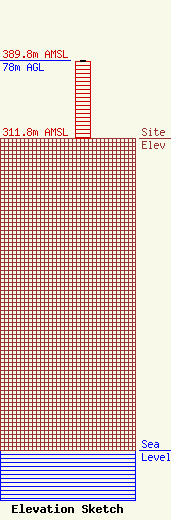
Site Elevation: 311.8 meters (1023 ft) |
| Height of Structure: 77.1 meters (253 feet) |
| Overall Height Above Ground: 78 meters (256 feet) |
| Overall Height Above Mean Sea Level: 389.8 meters (1279 feet) |
| Owner Info | Burbach of WV, LLC
1370 Washington Pike, Suite 406
Bridgeville, PA 15017
(412) 221-1629
nagalli1@msn.com |
| Info |
