|
|
Antenna Structure Registration 1035789 |
 |
Registration Info | Registration Number: 1035789 |
| File Number: A1292681 |
| Status: Constructed |
| Date Constructed: 01/01/1950 |
| NEPA: N |
Structure Info
| Structure Type: TOWER |
| Structure Coordinates: 39-27-48.0 N 77-59-10.0 W (NAD 83) |
| Structure Coordinates: 39-27-47.6 N 77-59-11.0 W (Converted to NAD 27) |
| Structure Address: 1606 W King St |
| Structure City: Martinsburg, WV |
| Structure County: Berkeley County |
| Painting & Lighting Info |
FCC Paragraph(s): 1, 3, 11, 21 |
| Elevation Info |
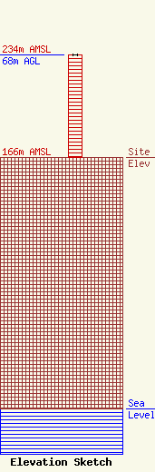
Site Elevation: 166 meters (545 ft) |
| Height of Structure: 68 meters (223 feet) |
| Overall Height Above Ground: 68 meters (223 feet) |
| Overall Height Above Mean Sea Level: 234 meters (768 feet) |
| Owner Info | West Virginia Radio Corporation
1251 Earl L Core Rd
Morgantown, WV 26505
(304) 292-2222
ken@wvradio.com |
| Contact Info | West Virginia Radio Corporation
1251 Earl L Core Rd
Morgantown, WV 26505
Kenneth Tennant
(304) 292-2222
ken@wvradio.com |
