|
|
Antenna Structure Registration 1035897 |
 |
Registration Info | Registration Number: 1035897 |
| File Number: A1075040 |
| Status: Constructed |
| Date Constructed: 07/01/1997 |
| NEPA: N |
Structure Info
| Structure Type: TOWER |
| Structure Coordinates: 46-37-39.0 N 120-44-17.0 W (NAD 83) |
| Structure Coordinates: 46-37-39.6 N 120-44-12.7 W (Converted to NAD 27) |
| Structure Address: Cowiche Mountain 12 Km Se Of Naches |
| Structure City: Cowiche, WA |
| Structure County: Yakima County |
| Painting & Lighting Info |
FCC Paragraph(s): None |
| Elevation Info |
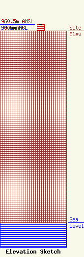
Site Elevation: 930 meters (3051 ft) |
| Height of Structure: 30.5 meters (100 feet) |
| Overall Height Above Ground: 30.5 meters (100 feet) |
| Overall Height Above Mean Sea Level: 960.5 meters (3151 feet) |
| Owner Info | Washington Broadband, Inc.
3201 W. Nob Hill Blvd.
Yakima, WA 98902-4960
(509) 853-0858
forbes.mercy@wabroadband.com |
| Contact Info | Washington Broadband, Inc.
3201 W. Nob Hill Blvd.
Yakima, WA 98902-4960
Forbes Mercy
(509) 853-0858
forbes.mercy@wabroadband.com |
