|
|
Antenna Structure Registration 1036067 |
 |
Registration Info | Registration Number: 1036067 |
| File Number: A1225814 |
| FAA Study: 2013-AGL-5013-OE |
| FAA Issue Date: 06/05/2013 |
| Status: Constructed |
| Date Constructed: 01/01/1966 |
Structure Info
| Structure Type: LTOWER |
| Structure Coordinates: 44-58-28.9 N 89-36-45.3 W (NAD 83) |
| Structure Coordinates: 44-58-29.0 N 89-36-44.9 W (Converted to NAD 27) |
| Structure Address: 1110 E Wausau Ave |
| Structure City: Wausau, WI |
| Structure County: Marathon County |
| Painting & Lighting Info |
FAA Circular #: 70/7460-1K |
FAA Chapters: 3, 4, 5, 12 |
| Elevation Info |
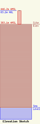
Site Elevation: 383.1 meters (1257 ft) |
| Height of Structure: 63.1 meters (207 feet) |
| Overall Height Above Ground: 63.1 meters (207 feet) |
| Overall Height Above Mean Sea Level: 446.2 meters (1464 feet) |
| Owner Info | Civic Media, Inc.
3535 University Ave.
Madison, WI 53705
(608) 292-4560
sage@civicmedia.us |
| Contact Info | Civic Media, Inc.
3535 University Ave.
Madison, WI 53705
(608) 292-4560
sage@civicmedia.us |
