|
|
Antenna Structure Registration 1036419 |
 |
Registration Info | Registration Number: 1036419 |
| File Number: A1376263 |
| FAA Study: 2025-ASO-21086-OE |
| FAA Issue Date: 01/22/2026 |
| Status: Constructed |
| Date Constructed: 01/01/1955 |
| NEPA: N |
Structure Info
| Structure Type: GTOWER |
| Structure Coordinates: 30-39-33.6 N 87-53-32.8 W (NAD 83) |
| Structure Coordinates: 30-39-32.9 N 87-53-32.8 W (Converted to NAD 27) |
| Structure Address: 29900 Wayside Dr |
| Structure City: Spanish Fort, AL |
| Structure County: Baldwin County |
| Painting & Lighting Info |
FAA Circular #: 70/7460-1M |
FAA Chapters: 4, 8, 15 |
Remarks: PRIOR STUDY 2018-ASO-8897-OE |
| Elevation Info |
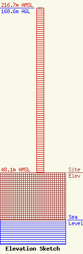
Site Elevation: 48.1 meters (158 ft) |
| Height of Structure: 168.6 meters (553 feet) |
| Overall Height Above Ground: 168.6 meters (553 feet) |
| Overall Height Above Mean Sea Level: 216.7 meters (711 feet) |
| Owner Info | Alabama Educational Television Commission
2112 11th Ave S
Birmingham, AL 35205
(800) 239-5233
dblack@aptv.org |
| Contact Info | Alabama Public Television
2112 11th Ave S
Birmingham, AL 35205
Daniel Black
(800) 239-5233
dblack@aptv.org |
