|
|
Antenna Structure Registration 1036421 |
 |
Registration Info | Registration Number: 1036421 |
| File Number: A1372969 |
| FAA Study: 2025-ASO-21088-OE |
| FAA Issue Date: 01/22/2026 |
| Status: Constructed |
| Date Constructed: 07/26/2011 |
| NEPA: N |
Structure Info
| Structure Type: GTOWER |
| Structure Coordinates: 33-29-6.4 N 85-48-31.8 W (NAD 83) |
| Structure Coordinates: 33-29-06.0 N 85-48-31.9 W (Converted to NAD 27) |
| Structure Address: Cheaha Mtn Cheaha State Park |
| Structure City: Delta, AL |
| Structure County: Cleburne County |
| Painting & Lighting Info |
FAA Circular #: 70/7460-1M |
FAA Chapters: 4, 8, 15 |
Remarks: PRIOR STUDY 2011-ASO-2835-OE |
| Elevation Info |
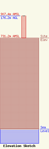
Site Elevation: 731.2 meters (2399 ft) |
| Height of Structure: 176.2 meters (578 feet) |
| Overall Height Above Ground: 176.2 meters (578 feet) |
| Overall Height Above Mean Sea Level: 907.4 meters (2977 feet) |
| Owner Info | Alabama Educational Television Commission
2112 11th Ave S
Birmingham, AL 35205
(800) 239-5233
dblack@aptv.org |
| Contact Info | Alabama Educational Television Commission
2112 11th Ave S
Birmingham, AL 35205
Daniel Black
(800) 239-5233
dblack@aptv.org |
