|
|
Antenna Structure Registration 1036422 |
 |
Registration Info | Registration Number: 1036422 |
| File Number: A1376322 |
| FAA Study: 2025-ASO-21089-OE |
| FAA Issue Date: 01/22/2026 |
| Status: Constructed |
| Date Constructed: 04/27/2005 |
| NEPA: N |
Structure Info
| Structure Type: GTOWER |
| Structure Coordinates: 32-22-55.0 N 86-17-33.3 W (NAD 83) |
| Structure Coordinates: 32-22-54.5 N 86-17-33.4 W (Converted to NAD 27) |
| Structure Address: 1300 Upper Wetumpka Rd |
| Structure City: Montgomery, AL |
| Structure County: Montgomery County |
| Painting & Lighting Info |
FAA Circular #: 70/7460-1M |
FAA Chapters: 4, 8, 15 |
Remarks: PRIOR STUDY 2004-ASO-4609-OE |
| Elevation Info |
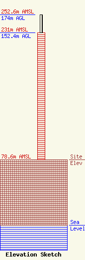
Site Elevation: 78.6 meters (258 ft) |
| Height of Structure: 152.4 meters (500 feet) |
| Overall Height Above Ground: 174 meters (571 feet) |
| Overall Height Above Mean Sea Level: 252.6 meters (829 feet) |
| Owner Info | Alabama Educational Television Commission
2112 11th Ave S
Birmingham, AL 35205
(800) 239-5233
dblack@aptv.org |
| Contact Info | Alabama Educational Television Commission
2112 11th Ave S
Birmingham, AL 35205
Daniel Black
(800) 239-5233
dblack@aptv.org |
