|
|
Antenna Structure Registration 1036444 |
 |
Registration Info | Registration Number: 1036444 |
| File Number: A1164522 |
| FAA Study: 2004-AEA-2548-OE |
| FAA Issue Date: 09/14/2004 |
| Status: Constructed |
| Date Constructed: 01/01/1953 |
| FAA EMI: N |
| NEPA: N |
Structure Info
| Structure Type: TOWER |
| Structure Coordinates: 42-30-22.8 N 75-29-32.3 W (NAD 83) |
| Structure Coordinates: 42-30-22.5 N 75-29-33.7 W (Converted to NAD 27) |
| Structure Address: Se Of Norwich At Intersection Of County Rd 33 And County Rd 38 |
| Structure City: Norwich Township, NY |
| Structure County: Chenango County |
| Painting & Lighting Info |
FAA Circular #: 70/7460-1K |
FAA Chapters: 3, 4, 5, 12 |
Remarks: PRIOR STUDY 1997-AEA-1333-OE |
| Elevation Info |
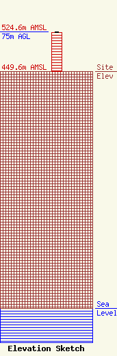
Site Elevation: 449.6 meters (1475 ft) |
| Height of Structure: 74.1 meters (243 feet) |
| Overall Height Above Ground: 75 meters (246 feet) |
| Overall Height Above Mean Sea Level: 524.6 meters (1721 feet) |
| Owner Info | Townsquare Media Oneonta, LLC
1 Manhattanville Road
Purchase, NY 10577
(203) 861-0900
fcccontact@townsquaremedia.com |
| Contact Info | Townsquare Media Oneonta, LLC
1 Manhattanville Road
Purchase, NY 10577
(203) 861-0900
fcccontact@townsquaremedia.com |
