|
|
Antenna Structure Registration 1036576 |
 |
Registration Info | Registration Number: 1036576 |
| File Number: A0098527 |
| FAA Study: 85-AEA-1157-OE |
| Status: Constructed |
| Date Constructed: 01/15/1989 |
| FAA EMI: N |
| NEPA: N |
Structure Info
| Structure Type: TOWER |
| Structure Coordinates: 38-57-44.0 N 77-1-35.0 W (NAD 83) |
| Structure Coordinates: 38-57-43.6 N 77-01-36.1 W (Converted to NAD 27) |
| Structure Address: Nw Corner 9th And Peabody |
| Structure City: Washington, |
| Structure County: District of Columbia |
| Painting & Lighting Info |
FCC Paragraph(s): A1, B, D, H, 3, 6, 15, 21, 23 |
| Elevation Info |
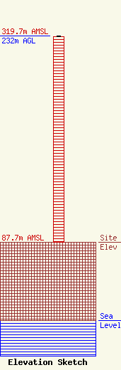
Site Elevation: 87.7 meters (288 ft) |
| Height of Structure: 231 meters (758 feet) |
| Overall Height Above Ground: 232 meters (761 feet) |
| Overall Height Above Mean Sea Level: 319.7 meters (1049 feet) |
| Owner Info | District of Columbia Office of Property Management
441Fourth Street, N.W., Suite 721N
Washington, DC 20001
(202) 724-4400
|
| Contact Info | District of Columbia Office of Property Management
441 Fourth Street, NW., Suite 721N
Washington, DC 20001
Kenneth Kimbrough
(202) 724-4400
|
