|
|
Antenna Structure Registration 1036587 |
 |
Registration Info | Registration Number: 1036587 |
| File Number: A1292682 |
| FAA Study: 91-AEA-0918-OE |
| FAA Issue Date: 07/18/1991 |
| Status: Constructed |
| Date Constructed: 01/01/1991 |
| FAA EMI: N |
| NEPA: N |
Structure Info
| Structure Type: TOWER |
| Structure Coordinates: 38-56-40.0 N 80-10-45.0 W (NAD 83) |
| Structure Coordinates: 38-56-39.6 N 80-10-45.7 W (Converted to NAD 27) |
| Structure Address: Approx 7 Km Se |
| Structure City: Buckhannon, WV |
| Structure County: Upshur County |
| Painting & Lighting Info |
FAA Circular #: 70/7460-1G |
FAA Chapters: 3, 4, 5, 9 |
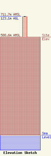
| Elevation Info |
Site Elevation: 588.6 meters (1931 ft) |
| Height of Structure: 121.9 meters (400 feet) |
| Overall Height Above Ground: 123.1 meters (404 feet) |
| Overall Height Above Mean Sea Level: 711.7 meters (2335 feet) |
| Owner Info | West Virginia Radio Corporation
1251 Earl L Core Rd
Morgantown, WV 26505
(304) 292-2222
ken@wvradio.com |
| Contact Info | West Virginia Radio Corporation
1251 Earl L Core Rd
Morgantown, WV 26505
Kenneth Tennant
(304) 292-2222
ken@wvradio.com |
