|
|
Antenna Structure Registration 1036626 |
 |
Registration Info | Registration Number: 1036626 |
| File Number: A0596512 |
| FAA Study: 71-ASO-1131-OE |
| FAA Issue Date: 06/07/1985 |
| Status: Constructed |
| Date Constructed: 01/01/1971 |
| FAA EMI: N |
| NEPA: N |
Structure Info
| Structure Type: TOWER |
| Structure Coordinates: 35-9-54.0 N 84-51-13.0 W (NAD 83) |
| Structure Coordinates: 35-09-53.7 N 84-51-13.2 W (Converted to NAD 27) |
| Structure Address: .14 Km Due N Of End Of Arnold St |
| Structure City: Cleveland, TN |
| Structure County: Bradley County |
| Painting & Lighting Info |
FCC Paragraph(s): 1, 3, 12, 21 |
Remarks: RED LIGHTS/PAINT |
| Elevation Info |
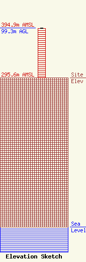
Site Elevation: 295.6 meters (970 ft) |
| Height of Structure: 98.4 meters (323 feet) |
| Overall Height Above Ground: 99.3 meters (326 feet) |
| Overall Height Above Mean Sea Level: 394.9 meters (1296 feet) |
| Owner Info | EAST TENNESSEE RADIO GROUP III, L.P.
112 JORDAN DRIVE
CHATTANOOGA, TN 37421
(423) 485-8987
|
| Contact Info | LEVENTHAL SENTER & LERMAN PLLC
2000 K STREET, NW, SUITE 600
WASHINGTON, DC 20006
BRIAN MADDEN
(202) 429-8970
BMADDEN@LSL-LAW.COM |
