|
|
Antenna Structure Registration 1036830 |
 |
Registration Info | Registration Number: 1036830 |
| File Number: A0452786 |
| FAA Study: 97-ACE-1543-OE |
| FAA Issue Date: 11/20/1997 |
| Status: Constructed |
| Date Constructed: 06/18/1986 |
| FAA EMI: N |
| NEPA: N |
Structure Info
| Structure Type: 3TA2 |
| Structure Coordinates: 41-33-31.0 N 93-34-46.0 W (NAD 83) |
| Structure Coordinates: 41-33-31.0 N 93-34-45.2 W (Converted to NAD 27) |
| Structure Address: Twr 2 2900 Southeast 22nd Street |
| Structure City: Des Moines, IA |
| Structure County: Polk County |
| Painting & Lighting Info |
FAA Circular #: 70/7460-1J |
FAA Chapters: 3, 4, 5, 13 |
| Elevation Info |
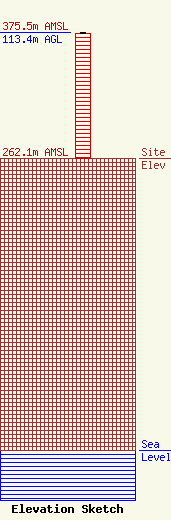
Site Elevation: 262.1 meters (860 ft) |
| Height of Structure: 112.5 meters (369 feet) |
| Overall Height Above Ground: 113.4 meters (372 feet) |
| Overall Height Above Mean Sea Level: 375.5 meters (1232 feet) |
| Owner Info | Saga Communications of Iowa, LLC
73 Kercheval Avenue, Suite 201
Grosse Pointe Farms, MI 48236
(313) 886-7070
gurbiel@sagacom.com |
| Contact Info | Smithwick & Belendiuk, P.C.
5028 Wisconsin Avenue, NW Suite 301
Washington, DC 20016
Gary Smithwick
(202) 363-4050
gsmithwick@fccworld.com |
