|
|
Antenna Structure Registration 1036835 |
 |
Registration Info | Registration Number: 1036835 |
| File Number: A1089270 |
| FAA Study: 2016-AGL-17283-OE |
| FAA Issue Date: 12/28/2016 |
| Status: Constructed |
| Date Constructed: 04/28/2017 |
| NEPA: N |
Structure Info
| Structure Type: GTOWER |
| Structure Coordinates: 43-2-8.0 N 89-30-25.0 W (NAD 83) |
| Structure Coordinates: 43-02-08.0 N 89-30-24.6 W (Converted to NAD 27) |
| Structure Address: 3250 South Gammon Road |
| Structure City: Madison, WI |
| Structure County: Dane County |
| Painting & Lighting Info |
FAA Circular #: 70/7460-1L |
FAA Chapters: 3, 4, 5, 12 |
Remarks: PRIOR STUDY 1997-AGL-5325-OE |
| Elevation Info |
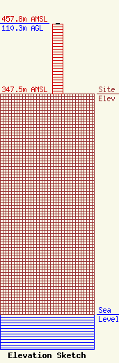
Site Elevation: 347.5 meters (1140 ft) |
| Height of Structure: 109.4 meters (359 feet) |
| Overall Height Above Ground: 110.3 meters (362 feet) |
| Overall Height Above Mean Sea Level: 457.8 meters (1502 feet) |
| Owner Info | UNIVERSITY OF NORTHWESTERN - ST PAUL
3003 SNELLING AVE N
ROSEVILLE, MN 55113
(651) 631-5009
sajones@unwsp.edu |
| Info |
