|
|
Antenna Structure Registration 1036900 |
 |
Registration Info | Registration Number: 1036900 |
| File Number: A0923827 |
| FAA Study: 2014-AGL-9870-OE |
| FAA Issue Date: 09/02/2014 |
| Status: Constructed |
| Date Constructed: 01/10/2000 |
| FAA EMI: N |
| NEPA: N |
Structure Info
| Structure Type: GTOWER |
| Structure Coordinates: 39-33-1.0 N 87-28-32.0 W (NAD 83) |
| Structure Coordinates: 39-33-00.9 N 87-28-31.9 W (Converted to NAD 27) |
| Structure Address: 3775 W Dugger Ave |
| Structure City: West Terre Haute, IN |
| Structure County: Vigo County |
| Painting & Lighting Info |
FAA Circular #: 70/7460-1K |
FAA Chapters: 3, 4, 5, 12 |
Remarks: PRIOR STUDY 1997-AGL-5895-OE |
| Elevation Info |
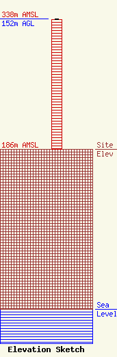
Site Elevation: 186 meters (610 ft) |
| Height of Structure: 151 meters (495 feet) |
| Overall Height Above Ground: 152 meters (499 feet) |
| Overall Height Above Mean Sea Level: 338 meters (1109 feet) |
| Owner Info | WORD POWER INC DBA = RADIO STATION WPFR-FM
3775 West Dugger Avenue
West Terre Haute, IN 47885-9794
(812) 535-1937
wpfr@joink.com |
| Contact Info | Word Power, Inc.
3775 West Dugger Avenue
West Terre Haute, IN 47885-9794
Paul Ford
(812) 535-1937
wpfr@joink.com |
