|
|
Antenna Structure Registration 1037391 |
 |
Registration Info | Registration Number: 1037391 |
| File Number: A1306631 |
| FAA Study: 2024-AEA-13651-OE |
| FAA Issue Date: 01/16/2025 |
| Status: Constructed |
| Date Constructed: 03/21/2011 |
| NEPA: N |
Structure Info
| Structure Type: GTOWER |
| Structure Coordinates: 38-37-49.0 N 76-3-24.1 W (NAD 83) |
| Structure Coordinates: 38-37-48.6 N 76-03-25.3 W (Converted to NAD 27) |
| Structure Address: Rt. 50 West (aka 2989 Ocean Gtwy) (000049) |
| Structure City: Trappe, MD |
| Structure County: Talbot County |
| Painting & Lighting Info |
FAA Circular #: 70/7460-1M |
FAA Chapters: 4, 8, 15 |
Remarks: PRIOR STUDY 2023-AEA-11245-OE |
Remarks: OM&L to remain the same as prior study = A MED-DUAL SYSTEM |
Remarks: PRIOR STUDY 2023-AEA-11245-OE |
Remarks: OM&L to remain the same as prior study = A MED-DUAL SYSTEM |
| Elevation Info |
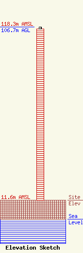
Site Elevation: 11.6 meters (38 ft) |
| Height of Structure: 105.5 meters (346 feet) |
| Overall Height Above Ground: 106.7 meters (350 feet) |
| Overall Height Above Mean Sea Level: 118.3 meters (388 feet) |
| Owner Info | American Towers LLC
10 Presidential Way
Woburn, MA 01801
(781) 926-4500
faa-fcc@americantower.com |
| Contact Info | American Towers LLC
10 Presidential Way
Woburn, MA 01801
(781) 926-4500
faa-fcc@americantower.com |
