|
|
Antenna Structure Registration 1037729 |
 |
Registration Info | Registration Number: 1037729 |
| File Number: A1252269 |
| FAA Study: 2008-AEA-1928-OE |
| FAA Issue Date: 04/21/2008 |
| Status: Constructed |
| Date Constructed: 09/18/2008 |
| FAA EMI: N |
| NEPA: N |
Structure Info
| Structure Type: 2TA1 |
| Structure Coordinates: 38-55-41.0 N 75-29-19.0 W (NAD 83) |
| Structure Coordinates: 38-55-40.6 N 75-29-20.3 W (Converted to NAD 27) |
| Structure Address: Twr 1 1666 Blairs Pond Rd |
| Structure City: Milford, DE |
| Structure County: Kent County |
| Painting & Lighting Info |
FAA Circular #: 70/7460-1K |
FAA Chapters: 4, 8, 12 |
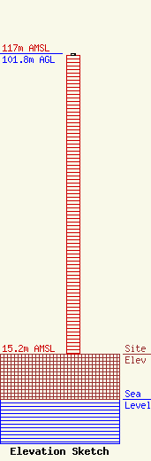
| Elevation Info |
Site Elevation: 15.2 meters (50 ft) |
| Height of Structure: 100.9 meters (331 feet) |
| Overall Height Above Ground: 101.8 meters (334 feet) |
| Overall Height Above Mean Sea Level: 117 meters (384 feet) |
| Owner Info | Forever Media of DE, LLC
274 Lakemont Park Blvd
Altoona, PA 16602
(412) 951-1525
fcccontact@forevermediainc.com |
| Contact Info | Forever Media of DE, LLC
274 Lakemont Park Blvd
Altoona, PA 16602
(412) 951-1525
fcccontact@forevermediainc.com |
