|
|
Antenna Structure Registration 1037731 |
 |
Registration Info | Registration Number: 1037731 |
| File Number: A1033762 |
| FAA Study: 85-AEA-1076-OE |
| FAA Issue Date: 01/30/1986 |
| Status: Constructed |
| Date Constructed: 09/12/1985 |
| FAA EMI: N |
| NEPA: N |
Structure Info
| Structure Type: TOWER |
| Structure Coordinates: 38-21-39.0 N 75-36-59.0 W (NAD 83) |
| Structure Coordinates: 38-21-38.6 N 75-37-00.3 W (Converted to NAD 27) |
| Structure Address: 919 Ellegood St |
| Structure City: Salisbury, MD |
| Structure County: Wicomico County |
| Painting & Lighting Info |
FCC Paragraph(s): 1, 3, 12, 21 |
Remarks: RED LIGHTS/PAINT |
| Elevation Info |
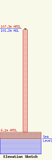
Site Elevation: 6.1 meters (20 ft) |
| Height of Structure: 100 meters (328 feet) |
| Overall Height Above Ground: 101.2 meters (332 feet) |
| Overall Height Above Mean Sea Level: 107.3 meters (352 feet) |
| Owner Info | Rothschild Broadcasting LLC
919 Ellegood Street
Salisbury, MD 21801
(410) 219-3500
rmrothschild@msn.com |
| Contact Info | Rothschild Broadcasting LLC
919 Ellegood Street
Salisbury, MD 21801
(410) 219-3500
rmrothschild@msn.com |
