|
|
Antenna Structure Registration 1037792 |
 |
Registration Info | Registration Number: 1037792 |
| File Number: A1139014 |
| FAA Study: 2018-ANE-708-OE |
| FAA Issue Date: 04/18/2018 |
| Status: Constructed |
| Date Constructed: 04/24/2018 |
| NEPA: N |
Structure Info
| Structure Type: GTOWER |
| Structure Coordinates: 43-25-0.3 N 70-48-15.2 W (NAD 83) |
| Structure Coordinates: 43-25-00.0 N 70-48-17.0 W (Converted to NAD 27) |
| Structure Address: Mount Hope Rd |
| Structure City: Sanford, ME |
| Structure County: York County |
| Painting & Lighting Info |
FAA Circular #: 70/7460-1L |
FAA Chapters: 3, 4, 5, 12 |
Remarks: PRIOR STUDY 2002-ANE-811-OE |
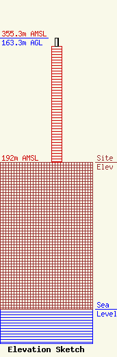
| Elevation Info |
Site Elevation: 192 meters (630 ft) |
| Height of Structure: 152 meters (499 feet) |
| Overall Height Above Ground: 163.3 meters (536 feet) |
| Overall Height Above Mean Sea Level: 355.3 meters (1166 feet) |
| Owner Info | Maine Public Broadcasting Corp
1450 Lisbon St.
Lewiston, ME 04240
(207) 404-5118
jmahaney@mainepublic.org |
| Contact Info | Maine Public Broadcasting Corp
63 Texas Ave
Bangor, ME 04401
Jeffrey Mahaney
(207) 404-5118
jmahaney@mainepublic.org |
