|
|
Antenna Structure Registration 1037803 |
 |
Registration Info | Registration Number: 1037803 |
| File Number: A0344437 |
| FAA Study: 97-AEA-1687-OE |
| FAA Issue Date: 09/11/1997 |
| Status: Constructed |
| Date Constructed: 01/01/1977 |
| FAA EMI: N |
| NEPA: N |
Structure Info
| Structure Type: TOWER |
| Structure Coordinates: 39-52-12.0 N 80-7-59.9 W (NAD 83) |
| Structure Coordinates: 39-52-11.7 N 80-08-00.7 W (Converted to NAD 27) |
| Structure Address: On State Rt 19, 2.3 Mi Se Of Morrisville |
| Structure City: Waynesburg, PA |
| Structure County: Greene County |
| Painting & Lighting Info |
FAA Circular #: 70/7460-1J |
| FAA Chapters: 3, 4, 5, 13 |
| Elevation Info |
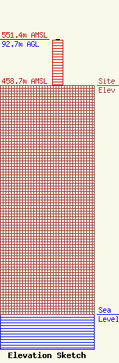
Site Elevation: 458.7 meters (1505 ft) |
| Height of Structure: 91.3 meters (300 feet) |
| Overall Height Above Ground: 92.7 meters (304 feet) |
| Overall Height Above Mean Sea Level: 551.4 meters (1809 feet) |
| Owner Info | Broadcast Communications, Inc.
990
Greensburg, PA 15601
(412) 823-7000
|
| Info |
