|
|
Antenna Structure Registration 1037926 |
 |
Registration Info | Registration Number: 1037926 |
| File Number: A0838348 |
| FAA Study: 88-ASW-1394-OE |
| FAA Issue Date: 11/30/1988 |
| Status: Constructed |
| Date Constructed: 10/01/1989 |
| FAA EMI: N |
| NEPA: N |
Structure Info
| Structure Type: TOWER |
| Structure Coordinates: 34-22-20.0 N 93-2-52.0 W (NAD 83) |
| Structure Coordinates: 34-22-19.7 N 93-02-51.4 W (Converted to NAD 27) |
| Structure Address: Atop Jack Mountain Hwy 128 16 Km Nw |
| Structure City: Malvern, AR |
| Structure County: Hot Spring County |
| Painting & Lighting Info |
FCC Paragraph(s): 1, 3, 4, 13, 21 |
Remarks: RED LIGHTS/PAINT |
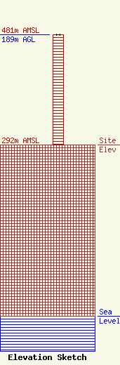
| Elevation Info |
Site Elevation: 292 meters (958 ft) |
| Height of Structure: 189 meters (620 feet) |
| Overall Height Above Ground: 189 meters (620 feet) |
| Overall Height Above Mean Sea Level: 481 meters (1578 feet) |
| Owner Info | C & W Communications
2500
Hot Springs, AR 71913
Steve Gill
(501) 609-0900
sgill@wletc.com |
| Contact Info | Mid South Communications
2500
Hot Springs, AR 71914
Steve Gill
(501) 609-0900
sgill@wletc.com |
