|
|
Antenna Structure Registration 1038716 |
 |
Registration Info | Registration Number: 1038716 |
| File Number: A1352645 |
| FAA Study: 2025-AGL-14630-OE |
| FAA Issue Date: 12/31/2025 |
| Status: Constructed |
| Date Constructed: 09/25/1983 |
| NEPA: N |
Structure Info
| Structure Type: GTOWER |
| Structure Coordinates: 48-3-0.0 N 101-20-33.6 W (NAD 83) |
| Structure Coordinates: 48-02-60.0 N 101-20-32.0 W (Converted to NAD 27) |
| Structure Address: 0.2 Mi Sw (230 Deg) Of Intersection Between 177th Ave Sw And 30th St Sw. |
| Structure City: Minot, ND |
| Structure County: Ward County |
| Painting & Lighting Info |
FAA Circular #: 70/7460-1M |
FAA Chapters: 3, 4, 5, 15 |
Remarks: PRIOR STUDY 1999-AGL-776-OE |
| Elevation Info |
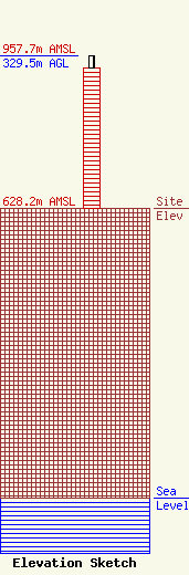
Site Elevation: 628.2 meters (2061 ft) |
| Height of Structure: 304.8 meters (1000 feet) |
| Overall Height Above Ground: 329.5 meters (1081 feet) |
| Overall Height Above Mean Sea Level: 957.7 meters (3142 feet) |
| Owner Info | Nexstar Media Inc.
545 E. John Carpenter Freeway
Irving, TX 75062
(972) 373-8800
jasroberts@nexstar.tv |
| Contact Info | Nexstar Media Inc.
545 E. John Carpenter Freeway
Irving, TX 75062
Jason Roberts
(972) 373-8800
jasroberts@nexstar.tv |
