|
|
Antenna Structure Registration 1038784 |
 |
Registration Info | Registration Number: 1038784 |
| File Number: A1231502 |
| FAA Study: 2022-AWP-10560-OE |
| FAA Issue Date: 11/10/2022 |
| Status: Constructed |
| Date Constructed: 12/10/1987 |
| NEPA: N |
Structure Info
| Structure Type: LTOWER |
| Structure Coordinates: 38-38-53.0 N 121-28-41.4 W (NAD 83) |
| Structure Coordinates: 38-38-53.3 N 121-28-37.6 W (Converted to NAD 27) |
| Structure Address: 719 North Market Blvd. |
| Structure City: Sacramento, CA |
| Structure County: Sacramento County |
| Painting & Lighting Info |
FCC Paragraph(s): 1, 3, 4, 13, 21 |
Remarks: PRIOR STUDY 2015-AWP-1343-OE |
Remarks: Continue As Is OM&L = PAINT/RED LIGHTS |
Remarks: PRIOR STUDY 2015-AWP-1343-OE |
Remarks: Continue As Is OM&L = PAINT/RED LIGHTS |
| Elevation Info |
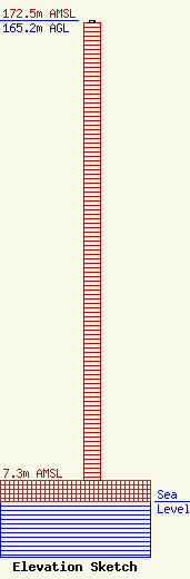
Site Elevation: 7.3 meters (24 ft) |
| Height of Structure: 164.3 meters (539 feet) |
| Overall Height Above Ground: 165.2 meters (542 feet) |
| Overall Height Above Mean Sea Level: 172.5 meters (566 feet) |
| Owner Info | American Towers LLC
10 Presidential Way
Woburn, MA 01801
(781) 926-4500
faa-fcc@americantower.com |
| Contact Info | American Towers LLC
10 Presidential Way
Woburn, MA 01801
(781) 926-4500
faa-fcc@americantower.com |
