|
|
Antenna Structure Registration 1039823 |
 |
Registration Info | Registration Number: 1039823 |
| File Number: A1248730 |
| FAA Study: 2002-ASW-6164-OE |
| FAA Issue Date: 01/09/2003 |
| Status: Constructed |
| Date Constructed: 02/07/2003 |
| FAA EMI: N |
| NEPA: N |
Structure Info
| Structure Type: TOWER |
| Structure Coordinates: 35-11-1.0 N 94-7-45.0 W (NAD 83) |
| Structure Coordinates: 35-11-00.7 N 94-07-44.3 W (Converted to NAD 27) |
| Structure Address: 1.23 Miles Se Of Intersection Of Auburn And Burnsville Roads |
| Structure City: Milltown, AR |
| Structure County: Sebastian County |
| Painting & Lighting Info |
FAA Circular #: 70/7460-1K |
FAA Chapters: 4, 6, 12 |
Remarks: PRIOR STUDY 1990-ASW-1341-OE |
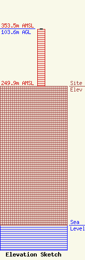
| Elevation Info |
Site Elevation: 249.9 meters (820 ft) |
| Height of Structure: 102.7 meters (337 feet) |
| Overall Height Above Ground: 103.6 meters (340 feet) |
| Overall Height Above Mean Sea Level: 353.5 meters (1160 feet) |
| Owner Info | PHARIS BROADCASTING, INC.
323 North Greenwood Avenue
908
FORT SMITH, AR 72902
(479) 242-1047
karenpharis40@yahoo.com |
| Contact Info | Wilkinson Barker Knauer, LLP
1800 M Street, NW
Washington, DC 20036
Davina Sashkin
(202) 383-3428
dsashkin@wbklaw.com |
