|
|
Antenna Structure Registration 1040029 |
 |
Registration Info | Registration Number: 1040029 |
| File Number: A0047109 |
| FAA Study: 84-AEA-2132-OE |
| FAA Issue Date: 04/30/1985 |
| Status: Constructed |
| Date Constructed: 08/02/1985 |
| NEPA: N |
Structure Info
| Structure Type: TOWER |
| Structure Coordinates: 39-36-59.0 N 76-51-37.0 W (NAD 83) |
| Structure Coordinates: 39-36-58.6 N 76-51-38.1 W (Converted to NAD 27) |
| Structure Address: 1552 N Main St |
| Structure City: Hampstead, MD |
| Structure County: Carroll County |
| Painting & Lighting Info |
FAA Circular #: 70/7460-1F |
FAA Chapters: 4, 7, 9 |
Remarks: DUAL HIGH INTENSITY WHITE AND RED LIGHTS. |
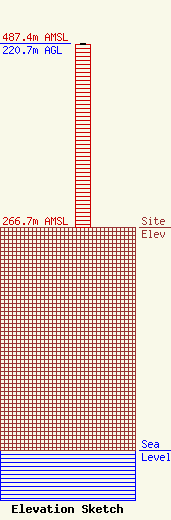
| Elevation Info |
Site Elevation: 266.7 meters (875 ft) |
| Height of Structure: 219.8 meters (721 feet) |
| Overall Height Above Ground: 220.7 meters (724 feet) |
| Overall Height Above Mean Sea Level: 487.4 meters (1599 feet) |
| Owner Info | SHAMROCK COMMUNICATIONS INC DBA = RADIO STATION WGRX FM
149 PENN AVE
SCRANTON, PA 18505
(410) 771-8484
|
