|
|
Antenna Structure Registration 1040569 |
 |
Registration Info | Registration Number: 1040569 |
| File Number: A1178140 |
| FAA Study: 03-OE-2109 |
| FAA Issue Date: 01/01/1975 |
| Status: Constructed |
| Date Constructed: 01/01/1960 |
| FAA EMI: N |
| NEPA: N |
Structure Info
|
| Structure Coordinates: 46-48-37.0 N 100-50-11.0 W (NAD 83) |
| Structure Coordinates: 46-48-37.0 N 100-50-09.5 W (Converted to NAD 27) |
| Structure Address: Us Hwy 10 3 Mi E & S |
| Structure City: Mandan, ND |
| Structure County: Morton County |
| Painting & Lighting Info |
FCC Paragraph(s): 1 |
Remarks: RED LIGHTS/PAINT PER NOS 35-0040. |
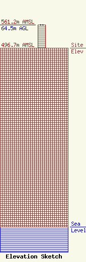
| Elevation Info |
Site Elevation: 496.7 meters (1630 ft) |
| Height of Structure: 63.9 meters (210 feet) |
| Overall Height Above Ground: 64.5 meters (212 feet) |
| Overall Height Above Mean Sea Level: 561.2 meters (1841 feet) |
| Owner Info | Townsquare Media Bismarck, LLC
1 Manhattanville Road
Purchase, NY 10577
(203) 861-0900
fcccontact@townsquaremedia.com |
| Contact Info | Townsquare Media, Inc.
1 Manhattanville Road
Purchase, NY 10577
(203) 861-0900
fcccontact@townsquaremedia.com |
