|
|
Antenna Structure Registration 1040891 |
 |
Registration Info | Registration Number: 1040891 |
| File Number: A1341986 |
| FAA Study: 90-ASW-0140-OE |
| Status: Constructed |
| Date Constructed: 11/01/1990 |
| NEPA: N |
Structure Info
| Structure Type: TOWER |
| Structure Coordinates: 35-13-32.0 N 94-20-29.0 W (NAD 83) |
| Structure Coordinates: 35-13-31.7 N 94-20-28.2 W (Converted to NAD 27) |
| Structure Address: 2.5 Km Sw Of Old Jenny Lind |
| Structure City: Jenny Lind, AR |
| Structure County: Sebastian County |
| Painting & Lighting Info |
FAA Circular #: 70/7460-1G |
FAA Chapters: 3, 4, 5, 9 |
| Elevation Info |
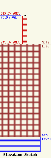
Site Elevation: 243.8 meters (800 ft) |
| Height of Structure: 74.6 meters (245 feet) |
| Overall Height Above Ground: 75.9 meters (249 feet) |
| Overall Height Above Mean Sea Level: 319.7 meters (1049 feet) |
| Owner Info | VB Nimbus, LLC
22 W Atlantic Avenue
Delray Beach, FL 33444
(561) 406-4015
fcc-faa@verticalbridge.com |
| Contact Info | VB Nimbus, LLC
22 W Atlantic Avenue
Delray Beach, FL 33444
Richard Hickey
(561) 406-4015
fcc-faa@verticalbridge.com |
