|
|
Antenna Structure Registration 1041136 |
 |
Registration Info | Registration Number: 1041136 |
| File Number: A0777886 |
| FAA Study: 95-ASO-2386-OE |
| FAA Issue Date: 09/04/1996 |
| Status: Constructed |
| Date Constructed: 10/03/1981 |
| FAA EMI: N |
| NEPA: N |
Structure Info
| Structure Type: 3TA1 |
| Structure Coordinates: 32-23-13.0 N 90-9-47.0 W (NAD 83) |
| Structure Coordinates: 32-23-12.5 N 90-09-46.7 W (Converted to NAD 27) |
| Structure Address: Twr 1 - 222 Beasley Road |
| Structure City: Jackson, MS |
| Structure County: Hinds County |
| Painting & Lighting Info |
FAA Circular #: 70/7460-1J |
FAA Chapters: 3, 4, 5, 13 |
Remarks: Removed expiration and final dates from determination. Scenario 2./jjs/case#635066 |
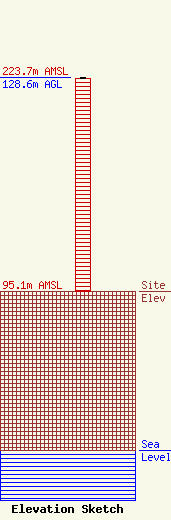
| Elevation Info |
Site Elevation: 95.1 meters (312 ft) |
| Height of Structure: 127.7 meters (419 feet) |
| Overall Height Above Ground: 128.6 meters (422 feet) |
| Overall Height Above Mean Sea Level: 223.7 meters (734 feet) |
| Owner Info | HI Management, LLC
2956
Meridian, MS 39302
(601) 383-4449
claymdn@aol.com |
| Contact Info | Latham & Watkins LLP
555 Eleventh Street, NW, Suite 1000
Washington, DC 20004
David Burns
(202) 637-2269
david.burns@lw.com |
