|
|
Antenna Structure Registration 1041335 |
 |
Registration Info | Registration Number: 1041335 |
| File Number: A0048715 |
| FAA Study: 78-ASO-1606-OE |
| FAA Issue Date: 11/01/1978 |
| Status: Constructed |
| Date Constructed: 10/27/1988 |
| NEPA: N |
Structure Info
| Structure Type: TOWER |
| Structure Coordinates: 36-52-54.0 N 87-30-44.0 W (NAD 83) |
| Structure Coordinates: 36-52-53.8 N 87-30-44.0 W (Converted to NAD 27) |
| Structure Address: 215 Dink Embry's Buttermilk Road |
| Structure City: Hopkinsville, KY |
| Structure County: Christian County |
| Painting & Lighting Info |
FAA Circular #: |
FCC Paragraph(s): 1, 3, 12, 21 |
Remarks: RED LIGHTS/PAINT |
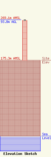
| Elevation Info |
Site Elevation: 175.3 meters (575 ft) |
| Height of Structure: 92.7 meters (304 feet) |
| Overall Height Above Ground: 93.8 meters (308 feet) |
| Overall Height Above Mean Sea Level: 269.1 meters (883 feet) |
| Owner Info | HOPKINSVILLE BROADCASTING COMPANY INC
709
HOPKINSVILLE, KY 42241-0709
(502) 885-5331
WHOP1@HOP-UKY.CAMPUS.MCI.NET |
