|
|
Antenna Structure Registration 1041349 |
 |
Registration Info | Registration Number: 1041349 |
| File Number: A1377825 |
| FAA Study: 2015-AGL-14930-OE |
| FAA Issue Date: 11/16/2015 |
| Status: Constructed |
| Date Constructed: 10/14/2015 |
| NEPA: N |
Structure Info
| Structure Type: GTOWER |
| Structure Coordinates: 44-15-53.6 N 101-39-57.3 W (NAD 83) |
| Structure Coordinates: 44-15-53.7 N 101-39-55.8 W (Converted to NAD 27) |
| Structure Address: Nw1/4, Sec36, T4n, R20e |
| Structure City: Billsburg, SD |
| Structure County: Haakon County |
| Painting & Lighting Info |
FAA Circular #: 70/7460-1K |
FAA Chapters: 4, 8, 12 |
Remarks: PRIOR STUDY 2014-AGL-14753-OE |
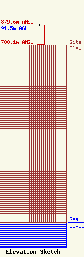
| Elevation Info |
Site Elevation: 788.1 meters (2586 ft) |
| Height of Structure: 91.5 meters (300 feet) |
| Overall Height Above Ground: 91.5 meters (300 feet) |
| Overall Height Above Mean Sea Level: 879.6 meters (2886 feet) |
| Owner Info | BIT/State Radio Communications Engineering
1302 E. Hwy. 14, Suite 8
Pierre, SD 57501
(605) 910-4978
fcc@state.sd.us |
| Contact Info | BIT/State Radio Communications Engineering
1302 E. Hwy. 14, Suite 8
Pierre, SD 57501
BIT-State Radio
(605) 910-4978
fcc@state.sd.us |
