|
|
Antenna Structure Registration 1041352 |
 |
Registration Info | Registration Number: 1041352 |
| File Number: A1377826 |
| FAA Study: 2015-AGL-14875-OE |
| FAA Issue Date: 11/06/2015 |
| Status: Constructed |
| Date Constructed: 09/14/2016 |
| NEPA: N |
Structure Info
| Structure Type: GTOWER |
| Structure Coordinates: 44-22-37.5 N 100-37-50.3 W (NAD 83) |
| Structure Coordinates: 44-22-37.6 N 100-37-48.8 W (Converted to NAD 27) |
| Structure Address: Sw1/4, Sec21, T5n, R29e, Stanley County |
| Structure City: Fort Pierre, SD |
| Structure County: Stanley County |
| Painting & Lighting Info |
FAA Circular #: 70/7460-1K |
FAA Chapters: 4, 8, 12 |
Remarks: Removed expiration date from determination. Scenario 1./jjs/case#635066 |
Remarks: FAA CHAPTERS 4,8,12; 70/7460-1K WITH BIRD LIGHTING DEVIATION SPECIAL CONDITION. |
Remarks: Removed expiration date from determination. Scenario 1./jjs/case#635066 |
Remarks: FAA CHAPTERS 4,8,12; 70/7460-1K WITH BIRD LIGHTING DEVIATION SPECIAL CONDITION. |
| Elevation Info |
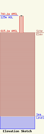
Site Elevation: 615.1 meters (2018 ft) |
| Height of Structure: 121.9 meters (400 feet) |
| Overall Height Above Ground: 125 meters (410 feet) |
| Overall Height Above Mean Sea Level: 740.1 meters (2428 feet) |
| Owner Info | BIT/State Radio Communications Engineering
1302 E. Hwy. 14, Suite 8
Pierre, SD 57501
(605) 910-4978
fcc@state.sd.us |
| Contact Info | BIT/State Radio Communications Engineering
1302 E. Hwy. 14, Suite 8
Pierre, SD 57501
BIT-State Radio
(605) 910-4978
fcc@state.sd.us |
